
San Felipe Area Weather
Sunrise: 7:33am Sunset: 7:33pm
Updated:03/16/26 at 4:31am
Moon Phase:Waning Crescent
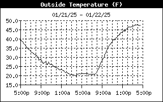


High Temperature
Low Temperature
60.9°F at 12:00a
51.5°F at 4:28a
High Humidity
Low Humidity
45% at 2:47a
39% at 12:45a
High Dewpoint
Low Dewpoint
37.0°F at 12:04a
28.0°F at 4:31a
High Wind Speed
34.0 mph at 3:19a
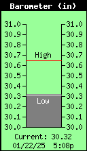
High Barometer
Low Barometer
30.141 in at 4:29a
29.958 in at 12:17a
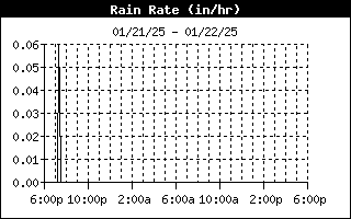
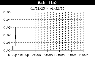
High Rain Rate
0.00 in/hr at ----
High Heat Index
58.0°F at 12:00a
Current Regional Conditions |
Daily Climate Information |
Local/Regional/National Forecast Information |
Severe Weather
» SPC Outlook |

Storm Chasing Information |
Tropical Weather |
Station Archives |
| MAPS & SATELLITE IMAGES |
|
|||


