San Felipe Area Weather

Current Conditions
Sunrise: 6:40am Sunset: 8:02pm  

Updated:05/02/26 at  9:01pm  

Moon Phase: Full Moon


Temperature
65.1°F
Humidity
81%
Dewpoint
59.1°F
Wind
NW at 0.0 mph Gusts to 0.0 mph
Barometer
30.119 in & Rising Slowly
Today's Rain
0.00 in
Rain Rate
0.00 in/hr
Storm Total
0.00 in
Monthly Rain
3.36 in
Yearly Rain
19.02 in
Wind Chill
65.1°F
Heat Index
65.7°F
Today's Highs/Lows

High Temperature

Low Temperature

79.6°F   at   6:52p

52.6°F  at    6:51a

High Humidity

Low Humidity

94%    at  12:00a

45%   at   6:47p

High Dewpoint

Low Dewpoint

60.0°F   at   8:26p

51.0°F  at   5:46a

High Wind Speed

17.0 mph   at  12:55a

High Barometer

Low Barometer

30.180 in   at  12:21p

30.011 in  at   2:51a

High Rain Rate

0.00 in/hr   at  ----

High Heat Index

79.0°F   at   6:42p

Current Regional Conditions

  • Weather Data Viewer
  • KHGX NEXRAD Radar Image
  • KHGX NEXRAD Radar Loop
  • KEWX NEXRAD Radar Image
  • South Texas Current Conditions
  • Houston NWS
  • Harris County Flood Control District
  • San Jacinto River Authority
  • Lower Colorado River Authority
  • Brazos River Authority

Daily Climate Information

  • Daily Climate Report
  • National Daily Weather Maps

Local/Regional/National Forecast Information

  • Forecast Discussion
  • San Felipe Forecast
  • Central Texas Forecast
  • Forecast Lab
  • 6-10 Day Outlook
  • 8-14 Day Outlook
  • 30 Day Outlook
  • 90 Day Outlook
  • Pivotal Weather

Severe Weather

    » SPC Outlook

  • Mesoscale Analysis Page
  • underthemeso
  • Storm/Nature Photography

Storm Chasing Information

  • Midwest DERECHO 8/10/2020 Detailed analysis
  • Southeast Texas DERECHO 5/16/2024 analysis
  • Storm Prediction Center
  • West Texas Mesonet
  • Storm Track.Org
  • Severe Studios
  • Twister Data

Weather Data Sites

  • Houston NWS
  • Central Texas High Res Sat.
  • South Texas Current Conditions
  • US Surface Map
  • HGX Radar
  • 1km High Resolution Satellite/Radar
  • GOES EAST Visible Satellite Image
  • GOES EAST Infrared Satellite Image
  • Low Cloud/Fog Map Loop
  • Geo Color Map
  • Infrared Satellite Image
  • Water Vapor Image
  • Continental U.S. Visible Satellite
  • Continental Infrared Satellite Short Wave
  • Continental Infrared Satellite Long Wave
  • Continental Low level Water vapor
  • Continental Mid level Water vapor
  • Continental High level Water vapor
  • KHGX NEXRAD Radar Image
  • KHGX NEXRAD Radar Loop
  • KEWX NEXRAD Radar Image
  • Upper Air Sounding Data
  • 200 mb Upper Air Analysis
  • 250 mb Upper Air Analysis
  • 300 mb Upper Air Analysis
  • 500 mb Upper Air Analysis
  • 700 mb Upper Air Analysis
  • 850 mb Upper Air Analysis
  • 925 mb Upper Air Analysis
  • Tropical Atlantic View Daytime Loop Goes 16
  • Texas Visible Satellite Loop
  • Mesoscale Analysis Page

Tropical Weather

  • Tropical Prediction Center
  • Additional Tropical Data
  • Atlantic Ocean Sea Surface Temps
  • Tropical Atlantic Infrared Satellite Loop
  • Tropical Discussion
  • Galveston Webcams
  • South Padre Bay Cam
  • South Padre Surf Cam
  • South Padre Beach Cam

Station Archives

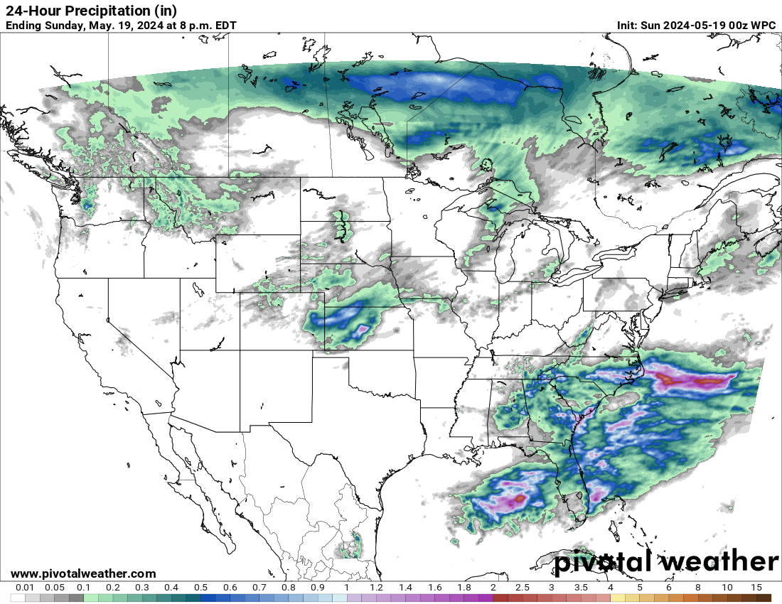
MAPS & SATELLITE IMAGES


free counters